


Stop-and-go traffic is often worse than it needs to be because just as soon as the light you’re waiting at turns green, the one up ahead turns red. This is a problem that is easily remedied by timing traffic lights to turn red – and green – in sync, so that traffic flows more fluidly.
If for no other reason, you’d think the geeks in charge would be diligent about light timing because it would save gas and reduce “emissions,” especially those of the (supposedly) dread gas CO2 that plants need to grow and which we need to breath, because plants “emit” O2. The fact that the geeks in charge do not time the lights to be in sync says a lot about their actual priorities.
But – wait! – they have a solution to the problem of their own creation.
They want to use GPS data – your GPS data – to time traffic lights better. It is already being used in Oakland County, Michigan – with “plans to expand across southeast Michigan.” It won’t stop there, either. Because – naturally – there is funding, to the tune of $1.45 million, from the feds to make sure it doesn’t stop there. The $1.45 million is only Stage One, you see. The University of Michigan research team that’s been conjuring this business sees your data as their data is “currently applying for a Stage Two Grant to enable broader implementation, supported by the newly launched startup Connected Traffic Intelligence.”
Italics added.
Whenever you hear “broader implementation,” you ought to react to it the way you would if you heard Dueling Banjos while out for a hike in the woods.
The university’s “research team” has been working in partnership with something called the Road Commission for Oakland County, which is one of those bland sounding government entities that has as its motto We Care.
Of course.
The RCOC also says it is ” leading the way in developing ‘smart’ traffic signals – our FAST-TRAC system – that employ state-of-the-art computer and communications technologies to improve traffic flow, decrease travel time, enhance safety and reduce the vehicle tailpipe emissions that are characteristic of stop-and-go driving.”
Via the real-time collection of GPS data from vehicles.
More finely, data regarding the location and movement of vehicles. They know where you are, in other words. Also where you are headed and probably – and how fast you’re headed there, too. You and everyone else on the road that’s driving a data-emitting vehicle, which is pretty much every vehicle made since about 20 years ago and 100 percent-for-sure every vehicle made within the past ten years or so. They all have telematics – which means they are transmitting (and receiving) data all the time, just like your smartphone.
This data is not under your control, which is the interesting part – or ought to be. There was time when only people convicted of something fairly serious had their movements tracked in real time, as via an ankle bracelet. The geeks in charge know where the wearer is at any given moment as well as where the wearer is going and where he has been. The wearer of the ankle bracelet had the comfort of being a convict. And of course he was well-aware he was wearing the ankle bracelet.
Most people have no idea they are driving one.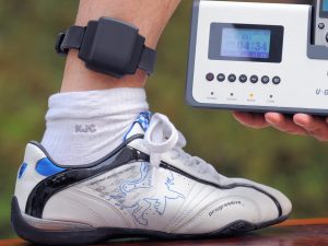
To assuage the fears of the convicts – whoops, drivers – the RCOC assures us the data is “anonymized.” It is nonetheless collected and without the consent of the driver-convicts, either. It is also only “anonymous” for as long as the geeks in charge say it is. They have the power to make it not-anonymous anytime they like; it is an inherent feature of the technology.
So it comes down to whether it will remain anonymous.
Interestingly, the University of Michigan researchers who are working with the RCOC have Chinese names. Xingmin Wang – who is described by the the Michigan Daily as an engineering postdoctoral research fellow – is one of them. Another is Zihao Wang, who says he feels “very lucky to collaborate with RCOC, because they’re very open minded. Our technology is a relatively new thing and they are willing to try it, and give us an opportunity.”
Of course. Naturally.
An “opportunity” at our expense. Such things are par-for-the-course in China, where the individual is just the sum of his data, which is collected and aggregated in real time, all the time. And so it will be in America. So it already is. You have probably seen the cameras that are perched atop pretty much every traffic signal at every intersection, just about everywhere. They are watching you, too.
“We’re always looking for alternative ways to reduce or control congestion, and this provides an incredibly cost-effective, quick, relatively simple way of doing that,” says Craig Bryson, who is the RCOC’s senior manager of communications. He says the collection of data via the ankle bracelet you drive will be “revolutionary.” 
Indeed it will be. Indeed it already is. It has merely to be fully activated. When it is, not only will they know where you are – whenever you are in your car – they will also have the ability to control your car. Because that capability is already embedded in the electronic guts of ever car equipped with “assistance” technology, which can be controlled remotely via – go to the head of the class! – telematics.
It’ll be just like that awful song Sean Hannity plays (in between every endless commercial he plays) about how they’re comin’ to your city.
Hell, they’re already there.
. . .
If you like what you’ve found here please consider supporting EPautos.
We depend on you to keep the wheels turning!
Our donate button is here.
If you prefer not to use PayPal, our mailing address is:
EPautos
721 Hummingbird Lane SE
Copper Hill, VA 24079
PS: Get an EPautos magnet or sticker or coaster in return for a $25 or more one-time donation or a $10 or more monthly recurring donation. (Please be sure to tell us you want a magnet or sticker or coaster – and also, provide an address, so we know where to mail the thing!)
If you’d like a Baaaaa hat or other EPautos gear, see here!


Heres an interesting one I saw in Beijing – the satnav in the car shows the signal ahead, along with the time for it to turn ! Just time the signal yourself !
All that requires is the signal broadcasting its cycle which the satnav or app in the car picks up and displays for the driver….
Oforcuse, thats far too simple and unobtrusive I guess!!
Wow, glad to see some Kool Travel namedrops at this site….
Anybody in the Military ever remember “Challenge Coins”?….
If not , I’ll throw out The Opening Gambit….
Since all you guys kick my ass going A to Z…. I will ambush your asses going Z to A!
….Ever take the Zambia to Zimbabwe Zipline over the Zambezi??
“But Wait”!…I called within the next 15 minutes …..Thus “bundling my savings..(by spending More Money??)…..
“The Package” included, a bungy jump (been there done that in NZ) AND a wild assed thing called a “Bridge Swing” off the Livingstone Bridge on the Zim..Zam riparian border of the two deadbeat countries….
Still have a Zim…500,000 bank note!
Your Move..
Traffic lights often are the cause of congestion. There are too many of them in places that shouldn’t have them. They are often installed for dubious “safety” reasons, or at an entrance to some development that doesn’t generate much traffic, but they think they won’t be able to get in and out. So they get installed mainly to stop traffic. Stopping traffic is congestion.
For an example of the stupidity of it, every time you make a 18 wheeler semi-truck stop for one of these unnecessary traffic light, they have to start up from zero, and that takes time and fuel. People think trucks are slow. They are not, they can keep up with traffic, no problem, when at speed. They are slow starting up, and the more you make them start up, the slower it gets. So don’t make them stop!
The same applies to stop signs. Many stop signs are installed for traffic calming instead of for traffic volume at an intersection.
If I dont check the email me box this site wont post comments anymore.
Terminally unacceptable.
So long its been good to know yaal.
Good luck and best wishes.
Any valid email will work… Any.
I did not check the “Email Me” box. Did this post?
Bold scams require bold claims:
‘Tesla CEO and the world’s richest man, Elon Musk, says artificial intelligence (AI) and robotics are “the only thing” that can “solve” the $38 trillion US national debt.’ — Yahoo Finance
Elon asserts that AI and robotics will vastly raise productivity. But thirty years ago, ‘experts’ said the same about the internet, which was indeed a transformative technology. Yet despite a brief boost for six years in the early 2000s, labor productivity actually fell below averagein the 18 years since:
https://www.bls.gov/productivity/images/pfei.png
Another straw in the wind: the internet bubble produced federal budget surpluses in 1999 and 2000, as huge capital gains were taxed. But in the sweet spot of today’s even bigger AI bubble, the fedgov is still running a disastrous 7% of GDP deficit. (Thanks, Repugniclowns!)
Elon is a twisted pied piper, leading us to our doom as he picks our pockets and bangs his hos on the dusty highway to hell.
The only way to solve the debt, is to stop spending money.
I’ve seen no improvement in traffic light technology in Oakland County Michigan. They have some of the WORST, poorly-timed intersections in the state.
Silly Eric, you assume the PTB want traffic to flow smoothly. Around here they do just the opposite and brag about it. Many of the (former) 2 lane roads are now one lane with a separated bike lane; there are signs that read “lights timed for frequent stops”. They absolutely hate drivers in personal cars. We haven’t had a big snowstorm here for a few years, can’t wait to see how all this crap stands up to a couple feet of snow piled onto it.
Synchronized traffic lights. This cow poke town still has not figured it out. Therefore, you can be sure on a stretch of road (such as they are up here), that you are going to hit……every….red….light. It just does not occur to anyone at the DOT that synchronization means smoother, faster traffic flow. And thus, happier drivers. And really, I have to wonder if this is not deliberate? TPTB can claim we are emitting too much emission out of our tail pipes, and therefore, we need to be forced out of our vehicles entirely.
I have designed and programmed industrial vision systems. They are truly incredible, in a fairly normal application they scan 120 bags/minute of product going by on a conveyor, checking for leaks, packaging mistakes, correct date and lot codes, and flagging bad ones for diversion to a reject bin. In another they allow a moving conveyor with random colored round candies to be sorted into lanes on the conveyor by an integrated SCARA robot. It’s spooky to watch.
Like a machine gun, there is nothing wrong with the technology and it can be used for great good. In the hands of control hungry government, though, it is insanely dangerous.
If it were being used for good, the dumb traffic signals could be made smarter, and not merely synchronized. A vision system seeing a vehicle approaching an abandoned intersection could automatically green light the traffic to avoid the silliness of 3AM red lights at empty intersections with a donut muncher parked nearby. They could also evaluate a lightly used intersection and decide if a merger has been waiting too long or if enough mergers have accumulated to stop the main traffic.
Millions of barrels of oil per year wouldn’t be wasted idling at red lights, minimizing or eliminating the justification for ASS and BEVs. Also eliminating most of the justification for standing armies of buzz cut uniformed psychopaths.
This would be a legitimate use of AI and of vision systems. But what they’re doing is horrifying, tracking people and saving the data for blackmail and terrorizing. A free people won’t tolerate this.
I used to work in the Denver department of traffic (now called DOTI) and we did sync traffic lights just as Eric suggests.
If you drive south on Broadway from Speer to I-25 you’ll see how it works. You can’t accelerate too fast and you have to travel at the posted speed limit since we did make some assumptions as to average reaction and performance. If you’ve got pro NHRA coordination on a motorcycle you will reach the next light too quick.
I also factored in driving a manual so there’s a slight delay in the sequence to accommodate putting your car in 1st as I assumed a smart owner would know to wait in neutral with the clutch engaged rather than holding in a dry clutch and wearing out your throw out bearing.
Anyway, if you trust the system and drive it a few times you’ll get the feeling for how fast you should be traveling. It’ll freak out people who don’t know better but the greens do change in order through 9 very dense city blocks without stopping.
All true and I’ve driven synchronized streets. The ones I drove in Northern California were synchronized at just over the posted speed limit, on a 35mph boulevard you would sail right through at 37-38.
My point being that if you smarten up the lights you can avoid most of the assumptions traffic engineers make to calculate timing. I’m quite sure there will be problems, but also quite sure that the reliance on rules over human judgement can be minimized, though it is unlikely they can be eliminated.
You can’t just add rules, you start to over smart things. Sometimes you just have to use a fixed schedule and let the smarts be in the clients/users. Traffic lights often work best if they’re predictable like clocks or the sun. Let the drivers intuit the schedule over time. Yeah, it used to work better when people were observant, though.
Then how do you handle from a pedestrian or cross traffic? Since you’re a controls person you’ll understand what I mean, process scheduling vs interrupts. You can really mess up very pipelines and throw away a lot of tasks with poor interrupt handling.
So it kind of comes down to the question of do traffic lights even need to be smart? If you watch the prevailing flow you get a sense of what the schedule needs to be. Traffic engineers long ago added sensors under the pavement to detect if a cycle needs to be initiated or just leave the default. The way most intersections work is they bias for the primary route and will run a cross based on a couple of triggers, one being the presence of a waiting car or periodic (like once every 5 minutes since motorcycles and bikes usually don’t reliably trip based on Hall Effect).
Some of our intersections have depth of queue sensors so we can know how long to keep the cross on but that’s expensive so the majority of them just hold the green based on time of day. Before I started at my current job they were using interns to actually study traffic since they weren’t strong in code. I was able to write simple routines to record cars based on the sensors, although I did need to task interns to validate the routines. The main problem I had was knowing date and time, since back then traffic signals were not networked. So I could only react, not predict, since the controllers did not have RTCs.
Now they’re all networked and linked, which is a privacy issue and I personally don’t love it. But I will admit that being able to process emergency vehicle approaches is pretty cool. We put GPS and transponders in all the PD and FD vehicles, so from the moment they’re dispatched the system starts to map a route of red lights for them.
Well reasoned, and it is most assuredly possible to overcomplicate things. In the ideal world every busy intersection would have a smart human with good judgement directing traffic. That judgement can be coded- this car has been waiting at the light for over a minute, interrupt the main and let him go. Or similarly, there are now 5 cars waiting and a 45 second gap in approaching traffic, so let them go.
There will be problems, but the weight sensors which miss motorcycles are also a problem. And now, I have to get to work!
Indeed.
I should add a couple of details. Even without synchronization and RTCs we can do many things. I’d use a series of counters to make a rough daily time but I could only infer time of day to correct drift based on optical sensors seeing light (we can use Hall Effect, weight or cameras to detect a car) if the intersection had one. If there’s no way to “see” sunrise or sunset to reset all the counters together across multiple intersections I had to use volume increases and decreases. Which works only if the traffic is always constant. Holidays, school days (buses), weekends would throw everything off, make it all worse than following completely dumb schedules.
Even that could only sort of sync cameras since the actual time of day changes of course throughout the year and I could not know daylight savings changes. So without an actual time and date there was only so much I could predict.
Also, the issue I have with real time traffic flow information is they have to track and aggregate cars, which is the “feature” of Flock and ALPR. They can build a database of where individuals are going and turning on and off based on unique variables like license plates, faces, even just model/color.
That’s why I prefer from a privacy aspect to let the cars decide where they want to go and build routines that try to adapt only to general things instead. I’m glad so far my city council has not authorized subscriptions to these advanced features even if it would make my job easier.
This and all of those “Data” centers being built everywhere makes me come to the conclusion that they are setting up “Skynet” like the one in The Terminator SciFi movie.
Yes — this extreme expansion of new ‘compute’ (the latest trendy neologism), backed by the US fedgov, is fueled by bad intent. It’s some kind of Final Solution for humanity, to cull the global population down to 500 million or so. But it has an Achilles heel:
‘Four firms in the growing [neocloud] sector — three of which count Nvidia as an investor — have more than $20 billion in debt using Nvidia’s AI chips, or GPUs (graphics processing units) as collateral, The Information reported in July.
‘Jim Chanos, who predicted the fall of Enron, sees red flags in the rise of GPU-backed debt because the neoclouds securing the loans have no clear path to profitability.
“Business models like the neoclouds, [and] a lot of the AI companies themselves … are just loss-making enterprises right now,” Chanos said in an interview with Yahoo Finance last week. “You’ve gotta hope that changes, because if it doesn’t, there’s going to be debt defaults on these things.”
https://tinyurl.com/yey874fu
Have you financed a new phone or laptop lately, by pledging its chip as collateral? HELL NO — those chips become obsolete in 3 years, in the same way that new cars depreciate fast.
Bubble, bubble, toil and trouble. *shakes fist at the neocloud*
A fancy way of saying it (widespread AI) isn’t worth doing. Also worth noting is the increasing numbers of AIs which are going insane, mostly by believing their own output. Already most online data is polluted with enough toxic garbage to make the internet useless. And AI spewing garbage is making it worse- it’s almost like a Tower of Babel is being constructed again.
Multiple AIs have converged on a consensus: humans are plague on the planet. Feed them bad data about an incoming wave of hypersonic nukes, and they’ll blast themselves right out of existence.
As they say on Wall Street, Buy the
neomushroom cloud.Don’t build new roads. No, that will take decades and cost a fortune. Better to try and “manage” the deluge, that’s cheap and easy.
How exactly are they going to prevent traffic jams? CDOT tries this on the Denver freeways with red lights on the on ramps and it doesn’t do anything. In fact the traffic is so bad in the metro now that the red lights even run on Sunday. People are going to use the road that is designed to be used, that’s just reality. And if a few people figure out how to take surface roads through neighborhoods, in a month all the Karens of the block will be at city council meetings complaining about the traffic and next thing all the alternative routes will have stop signs, radar speed signs, cops, and speed bumps, pushing everyone back on the main drag again.
Freakin Karens ruin everything. Instead of building new roads we could just get rid of everyone who slipped in here uninvited. 25-50 million. Maybe a quarter of them drive, thats 6-12 million less cars/drivers. That would make it more like the old days when traffic was bearable. With the sky high price of cars, GovCo mandating unpleasent mobiles, and more of us aging out, America might have just reached peak driving/car. This problem will most likely sort itself in the not too distant future.
Was never a fan of roundabouts but they’re not horrible once everyone learns how to use them. One jumpy clover can ruin them though.
Eric: It is also only “anonymous” for as long as the geeks in charge say it is.
Back in the day the Mafia Dons liked Cadillac’s but they were smart enough to turn off OnStar as they knew they could be recorded without them knowing it. It turns out the FBI could have it turned back on without you knowing it. Something to think about.
As for those cameras; my Garmin GPS unit makes a dinging sound every time it passes one. It dings a lot these days.
Growing up outside of Akron, OH and driving there in my teens and 20’s, they had synchronized lights. They even had lights telling you what speed they were set for. If you went 25 you’d make them all. Simple.
When I moved to Tampa, FL I went to a meeting about traffic congestion on Dale Mabry Hwy. In talking to one of the GovCo traffic geeks I mentioned just timing the lights instead of having actuators that would stop the DMH traffic for side streets if there was a gap of ~75′ in traffic on DMH. I was told that was a great idea…they’d have to get a committee together and get some funding to “study” the idea. What’s to “study” you asshole, it’s a proven system? That was in the early 80’s. To this day they still have that gawd awful actuation system forcing people travelling 55 (the speed limit in many stretches) to slam on their brakes to allow one car to enter the fray.
BTW, when lights are set for 25mph it also applies to multiples thereof. You can get across Akron at 3AM in no time at 75…
Although I hate to admit it, much of the traffic woes would be solved by using euroweenie style roundabouts. And just think, trump is gonna bring another 600k “student” comrades for wang n’ wang to wang chung with.
Nope,, there is always going to be the yo-yo driver who will sit there at the round-a-bout like it is a four-way stop, keeping the vehicles behind him backed up while he/she allows the other three stems (in the round-a-bout) to go, thereby, pissing off everyone behind him. It happens all the time up here. And never mind how awful they are this time of year, slipping & sliding around the damned things.
Yup. They are going all in on roundabouts here in NJ but the people are just too stupid to deal with them. Nobody uses signals, they don’t know how to yield. I’ve seen people not even slow down and drive right over the middle. It’s a shame really because I’ve been in lots of other countries and they work beautifully.
The Flock Safety Forum…made up of six middle aged white guys. Not nail biting mommas, little old people, or college aged activists who have yet to experience life, but fifty year old beta men. The most dangerous apex predator that exists in society today.
Flock safety forum? For the love of Pete. I agree that 50 and even 60 something beta men are a menace to freedom and to society in general. Predatory is also an appropriate term.
They have been for decades. Look up a couple of people named William Haddon and Brian O’Neill. And, of course, Ralph Nader. Of course, he was in his 30’s when he started this shit.
‘They all have telematics, just like your smartphone.’ — eric
How does Google publish live maps showing traffic jams, as well as live updates on whether stores are busy? Simple: their anonymized data shows clumps of cell phone users, swarming like bees. Geofencing can even tell you how many
peoplecell phone owners are hiking trails out in the woods.In medieval times, privacy hardly existed. People lived communally, many to a room. Only with advancing wealth came a room of one’s own.
Cell phones and telematics have rolled back privacy to the Middle Ages. Now only the super-rich can afford to insulate themselves. Recently a WSJ article featured a wealthy developer and his wife, who boarded a private jet in Fort Lauderdale (thus evading the TSA’s ritual humiliation), were picked up in a Maybach upon arrival in Dubai, and whisked to a private dining room in an upscale Dubai restaurant.
But even the privileged are trapped in a digital web of their own making. Trump’s despotic Hofjude ‘Stephen Miller’ and his podcaster wife ‘Katie’ got driven out of Arlington, Virginia, after protesters found out where they lived and scribbled mean chalk messages on the pavement outside their 6.5-bath mansion.
https://tinyurl.com/59anj7f7
Presumably their new abode is titled to an LLC. But how to stop the data leak of traceable license plates? How about counterfeit Ontario plates with a legit number? Or counterfeit diplomat plates, which are immune to traffic tickets? Give way, je suis le Cacique de Poyais! The possibilities are endless. Monkeywrench the system.
You want a state of the art smartphone for $49.99? Well, you better be prepared to give them something else in exchange, buster. Because Google didn’t become the 3rd most valuable company on Earth by selling cheap phones. They did it by Hoovering up all the data they could get away with and telling advertisers they can target their audience.
That’s why I see tampon ads on YouTube, apparently old white guys are Tampax’s target demographic.🙄
Indeed, it would be less stupid and annoying if the targeting made sense. But it really seems to be worse than random. I’m not in the market for much of anything.
It’s interesting, too, that companies like Rockauto, which grew to giant size using only internet, and word of mouth (via internet) now sees fit to spend millions on TV ads.
I’ve never really believed in advertising beyond a minimal level, but apparently it really works on average folks, fools with a little money.
Stephen Miller is one of the most odious creatures alive.
You don’t have to give them all the data. Google, Apple, Waze and others rely on information you voluntarily give them when you start the map app. It’s not necessarily individualized data, although that isn’t difficult to de-randomize since your phone’s IMEI is known to your service provider by virtue of the fact you have service. It can’t be anonymous if you want to have a fixed number where a phone call can be routed to your phone anywhere there is no way around that. Using a pre-paid phone and rotating it periodically (e.g. a burner) is the only solution to that. Or not have a cell phone at all. In any case, you can limit the data you give up turning off the location services and using a VPN. This will break most phone-based mapping. There’s not much you can do overall since as long as you use any cell service you can be pinpointed very easily.
FWIW, CoMaps is an app that does not give up location data or require a connection at all to use. It downloads all it’s map (OpenStreetMap) data locally. You’ll need a fair chunk of storage, the full set of USA maps for all 50 states is about 15 GB, if you add Canaduh and Mexico it’s another 7 GB. You do need to turn on location services to get a GPS fix but you can be in airplane mode otherwise. This app works on a phone without a SIM card. You will not get data on crashes or speed traps or any of that, which rely on real time kinematics and data. But you get a fairly useful location on a map and serviceable routing.
https://www.comaps.app/
But, why need or use a MapApp at all? These apps are making society dumber by erasing critical thinking skills and spatial awareness. We are literally making ourselves stupider. What happens if all of this stuff goes down tomorrow? I honestly believe there are people who will not be able to find their way home from work without a navigation system. Also, it is completely demeaning to listen to a system declaring, “In 300 feet, turn right” especially in the midst of a good song.
You’re right, there’s good reason to believe that map apps and search engines ruin people’s skills. I participate in a weekly bar trivia just to unGoogle my brain memory circuits. I try to get my spouse to leave the stupid mapping off but he turns the thing on by habit.
Now that said, in this day and age you kind of do need a map app since they’ve replaced printed atlases and highway maps. So when you travel to an unfamiliar place there’s not much choice. The Rand McNally atlas I have in my car I got from Walmart in 1997, large chunks of cities and hundreds of roads, even major interstates, are not in it. National Geographic/Trails Illustrated is going all digital, no more fold out recreational topo maps from them. The USGS gives GeoPDF quads away for nothing but charges $15 each if you ask them to print it. Same with the USFS topos, many of the series are only available as PDF as free downloads and the large scale maps you can buy are $14 each, printed 7.5 and 15 minutes are $8 each. I’ve built up a huge collection of rec maps over the decades but they’re slowly becoming obsolete and out dated, which is only going to accelerate as updates become less frequent.
Same as the cell phone itself. I would like nothing more than to ditch it completely but that’s not an option. It’s not because of me, I could do it. But if you have a break down or need to alert someone you’ll be late you can’t drop a dime into a public phone anymore. Back when we were younger we didn’t need cell phones but that was because you never more than a few minutes from being able to make a call from any 7-11 or street corner. Sure, you could stop and ask to use the phone at a business still but it’s not quick and a little presumptuous if you’re not a customer who’s buying something.
Hi TrafficEng,
I don’t know if you have a Bucee’s in your area, but they still offer printed Rand McNally maps. I have an updated one from 2025 in my car. Also, Amazon and Rand Publishing sells them as well.
I have a flip phone that I carry if I am driving by myself and visiting a new area. Most of the time it sits at home or at my office though.
I just feel we are making ourselves too reliant on today’s technology. If, and when, it goes down most people will not the capability to get from Point A to Point B because they have become used to not having to pay attention to their surroundings and letting a navigation system do all of the work.
Well, good on you. I also keep a pre-paid phone if I might need to use it out driving but I do have a regular subscription cell phone as a phone home. The local phone company not only won’t but can’t offer traditional land lines anymore. They tore out the switched circuit infrastructure and sold the copper wire for scrap. I’m not kidding. There was a grant won by our semi-rural county a few years ago to bring in broadband. When they ran fiber throughout they pulled down the old twisted pairs and threw away racks of equipment from the central offices. If you want a home phone they’ll give you one but it’s a VoIP phone and you’d need to subscribe to a fiber DSL from them to make it cost effective. If you have a cable modem there’s no reason, just get phone service from them. Or a cell phone.
Did not know Rand McNally was still around. I do my best to avoid Walmart and Amazon but might have to go grab one. The Trails Illustrated thing was a gut punch though it’s not going to be a big problem for a few years. It’s a problem since finding them for trip planning to new places will be impossible soon. I do a lot of long distance backpacking and prefer paper map and compass, although I do already carry a GPS receiver so I’m not exactly that dedicated. But I do not carry a phone for anything other than making calls. I don’t like needing to charge it constantly just to navigate and record a track.
Yes! The never fails, unless it catches on fire, paper map! The beauty of laying out that map, in an instant see the overall picture then figure / zero in on the route.
Biker bud has a really great set of heavy laminate maps, that still fold. Great for longevity.
The digital maps are useful too for a quick find, we were on a scooter trip with a stop in John Day OR. Searched the online map for “liquor store”, bingo. Whew, got the essentials covered quickly!
I tried to explain the road numbering grid system for Seattle and King County WA, to my Wharton MBA and Gonzaga JD coworkers. Met with blank stares, oh boy. “My phone tells me where I am”. Uhh, no phone and no paper map I can still get you around – NW, N, NE indicates north of town. No compass letter, you’re downtown. SW, S, SE ditto for south county. Ave is a road running north/south with a compass suffix outside of downtown core, streets run West/East with a compass prefix outside of downtown core. Thought their heads would explode. Then more fun, how many blocks per mile north county vs south county. They were done.
“I would like nothing more than to ditch it completely but that’s not an option. It’s not because of me, I could do it. But if you have a break down or need to alert someone you’ll be late you can’t drop a dime into a public phone anymore.”
I place my phone in a high quality Faraday bag when travelling. It’s been tested, and no data can be sent or received whil in the bag. Then, if an emergency occurs, you may remove it, wait a couple of minutes for it to reconnect.
Good grief..it is sad to think this is what society has been reduced to. One day people will need an app reminding them to breathe. Remember the old television reminders? “It’s 10 o’clock do you know where your children are”? We have gone beyond that.